- Title
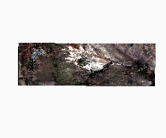
- Imagen falso color real. Sentinel 2024/04/24
- Abstract
Se realiza la composoción de la imagen falso color real con bandas del sensor Sentinel 2A con una resolucion de 10 metros
- License
- Public Domain (PD)
-
+ Works in the public domain may be used freely without the permission of the former copyright owner.
+ For more info see http://www.copyright.gov/help/faq/faq-definitions.html. - Creation Date
- Sept. 5, 2024, 4:39 a.m.
- Type
- Raster Data
- Keywords
- Category
- Imagery Base Maps Earth Cover
- Base maps. Examples: land cover, topographic maps, imagery, unclassified images, annotations.
- Regions
- Malargüe
- Approved
- Yes
- Published
- Yes
- Featured
- No
- DOI
- https://doi.org/10.48162/rev.46.040
- Attribution
- Viviana Seitz, Dario Soria
- Name
- Tecona
- Position
- None
- Organization
- None
- Location
- Voice
- None
- Fax
- None
- Identification Image
-


- Spatial Extent
- ---
- Projection System
- EPSG:22172
- Extension x0
- 2441906.7627
- Extension x1
- 2480572.2289
- Extension y0
- 6065201.0235
- Extension y1
- 6077185.8174
- Maintenance Frequency
- Data Is Updated As Deemed Necessary
- Restrictions
-
No dispone de otro tipo de restricciones
- Edition
- v.01
- Language
- Spanish
- Supplemental Information
No information provided
- Spatial Representation Type
- grid data is used to represent geographic data
- Name
- Tecona
- Position
- None
- Organization
- None
- Location
- Voice
- None
- Fax
- None
- Link Online
- /layers/Sentinel_20240424_reder:geonode:Sentinel_20240424_reder
- Metadata Page
- /layers/Sentinel_20240424_reder:geonode:Sentinel_20240424_reder/metadata_detail
- Thumbnail
- Imagen falso color real. Sentinel 2024/04/24.png
- Original Dataset
- Imagen falso color real. Sentinel 2024/04/24.zip
- JPEG
- Imagen falso color real. Sentinel 2024/04/24.jpg
- Imagen falso color real. Sentinel 2024/04/24.pdf
- PNG
- Imagen falso color real. Sentinel 2024/04/24.png
- GeoTIFF
- Imagen falso color real. Sentinel 2024/04/24.geotiff
- Legend
- Imagen falso color real. Sentinel 2024/04/24.png
- OGC WMS: geonode Service
- Geoservice OGC:WMS
- OGC WCS: geonode Service
- Geoservice OGC:WCS
- Name
- Tecona
- Position
- None
- Organization
- None
- Location
- Voice
- None
- Fax
- None